
Photogrammetry, often referred to as the science of making measurements from photographs, has a rich and intriguing history that spans centuries. From its humble beginnings to its modern-day applications, let’s delve into the evolution of this fascinating field.
Early Beginnings
The roots of photogrammetry can be traced back to the 19th century when French inventor Joseph Nicéphore Niépce captured the world’s first photograph in 1826. However, it wasn’t until the mid-1800s that the concept of photogrammetry began to take shape. A pivotal moment came in 1851 when French aerial photographer Aimé Laussedat conducted groundbreaking experiments in photogrammetry, laying the foundation for future developments in the field.
Advancements in Aerial Photography
The advent of manned flight in the early 20th century revolutionized the practice of photogrammetry. During World War I, aerial reconnaissance missions played a crucial role in military strategy, leading to significant advancements in aerial photography techniques. In the years that followed, pioneers like George Lawrence and Arthur Benton successfully employed photogrammetry for mapping and surveying purposes, further expanding its applications.
Technological Innovations
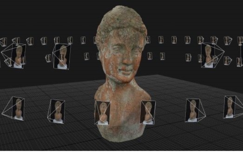
The latter half of the 20th century witnessed rapid technological advancements in photogrammetry. The introduction of stereo photogrammetry, which involves capturing overlapping aerial photographs from different vantage points to create 3D models, revolutionized mapping and surveying practices. Additionally, the development of digital cameras and computer software facilitated the automation of photogrammetric processes, making them more efficient and accurate than ever before.
Modern Applications
Today, photogrammetry plays a vital role in various industries, including cartography, urban planning, archaeology, and engineering. Its ability to generate detailed 3D models from aerial and terrestrial photographs has made it an indispensable tool for mapping terrain, monitoring environmental changes, and reconstructing historical sites. Moreover, advancements in drone technology have democratized access to photogrammetric techniques, allowing researchers, professionals, and hobbyists alike to harness its power for diverse applications.
Environmental Impact
Beyond its technological advancements and practical applications, photogrammetry also intersects with environmental conservation efforts. By providing accurate and detailed data about landscapes, ecosystems, and natural resources, photogrammetry aids in the monitoring and preservation of environmental assets. From assessing deforestation and habitat loss to tracking changes in coastal erosion and land use, photogrammetric techniques contribute to informed decision-making and sustainable management practices. As the global community strives to address pressing environmental challenges, photogrammetry stands as a valuable tool in the arsenal of conservationists, policymakers, and scientists working to protect our planet for future generations.

Looking Ahead
As we look to the future, the field of photogrammetry continues to evolve with advancements in artificial intelligence, machine learning, and computer vision. These technologies hold the promise of further enhancing the speed, accuracy, and scalability of photogrammetric processes, opening up new possibilities for innovation and discovery.
The history of photogrammetry is a testament to human ingenuity and perseverance. From its humble beginnings to its modern-day applications, photogrammetry has transformed the way we map, survey, and understand the world around us. As technology continues to advance, the future of photogrammetry shines bright with endless possibilities for exploration and discovery.